In Feb this year, the Department of Science and Technology (DST), Govt. of India issued guidelines for acquiring and producing geospatial data and geospatial data services including maps. It is said that through this, the government has significantly liberalised the erstwhile licensing policy to boost self-reliance on mapping technologies amid growing competence and in view of ‘Aatmnirbhar Bharat’.
Under the erstwhile guidelines, there were multiple agencies like Survey of India, Ministry of Defence, Ministry of Forests and DST with their own set of rules where it covered dissemination and licensing of maps, however now, the new set of guidelines replaced this multiple agency guidelines and brought the geospatial sector in an open competition.
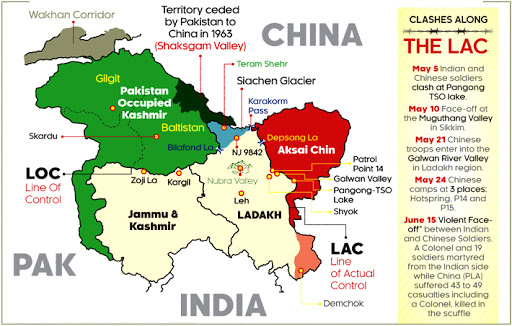
Maps have been a subject of controversy and a proof to claim a piece of land by states. Entities that deal in sectors where maps are of importance, it becomes difficult to keep the balance among different conflicts, perspectives and claims. In recent updates of political map of India, there are few changes done by Government of India after the abrogation of special status of J&K. After the abrogation of special status, J&K state has been divided into two separate Union territories but the same was not reflected on google map till many months. However, after a few months, google maps changed its map with respect to what it was showing earlier.
Earlier, there was also a line known as Line of Control. This LoC was originally known as a ceasefire line and revised after the Simla Agreement of 1972 and served as a de-facto border across which Pakistan administered Kashmir and Gilgit-Baltistan regions. The northern end point of LoC is NJ9842 beyond which it is called Actual Ground Positioning Line and runs till Indira Ridge in Siachen. Actual settlement of borders between India and Pakistan is still unresolved except on international boundary and that is why the dotted lines were earlier shown on maps particularly to distinguish it from international border.
About a year ago, one could see International boundary, LoC and AGPL on google maps available in almost all smart phones and over the internet, LoC was shown as dotted lines while international boundary as continuous line. But since last year (probably since April 2020), it seems that google has deleted the LoC from the map despite no change occurred on ground or upon physical possession.
A report published in The Washington post in Feb 2020 states that google executives officially denied the request for an interview but it is said that Google cartographers keep changing borders as and when it feels. Google said that ‘We remain neutral on issues of disputed regions and borders, and make every effort to objectively display the dispute in our maps using a dashed gray border line. In countries where we have local versions of Google Maps, we follow local legislation when displaying names and borders.’
However, google’s claim doesn’t seem fit to justify as in this case, google didn’t show the bifurcated state borders even until a few months ago and now updated it with the latest one while it had deleted the dotted LoC from map much earlier. It is not clear how showing the whole J&K and Ladakh territory along with dotted LoC could have violated any local policy of India.
Google has also faced criticism as its boundaries cannot be perfectly believed for sovereign hold of a country upon land showing in its boundary. This map changing technique by Google has no perfect answer. Google advocates the perspective of internal agencies like the UN but also talks about local government compliance where local map versions are available, however The Centre for Internet society describes how during Crimean referendum supporting independence, google changed the map to show Crimea independent in contrary to UN’s view.
Also, in the Google Mapathon competition in India, winner in 2013 was selected for mapping Pathankot city, however controversy erupted as Pathankot is a city with military vital areas and a case was filed against Google in Delhi by Survey of India for violation of National map policy and compromising national security. Case was later handed over to CBI but was made closed on account of lack of evidence. After the attack on Pathankot base in 2016, the issue re-emerged.
Present Indian users of google map won’t be able to see LoC as now google shows the boundary including Pakistan administered/occupied Kashmir and Gilgit-Baltistan without any dotted LoC line and in a single unit to all Indian users, however anyone from outside India will be able to see the LoC on google map.
It is clear that maps are political statements but its depiction is not a universal truth and instead depends on the perspectives of states and Google without a clear-cut policy and without considering any physical status of the administered area.

Ravi Nitesh is an engineer and freelance writer. He writes on issues of peace and human rights. He tweets @ravinitesh