HISTORICAL CORRECTION: The 2007 notification was based on the 2001 Census but was formally DEFERED and never brought into force for Manipur by Presidential Order dated 8th February 2008 (under Section 10A of the Delimitation Act, 2002), citing security conditions. The constituency boundaries currently operative in Manipur derive from the delimitation exercise conducted in 1973 under the Delimitation Act, 1972 – based on 1971 Census. The current 60-seat Assembly and the 19-ST/ 1-SC reserved seat configuration date from that 1973 exercise. Manipur’s electoral map is therefore over FIFTY YEARS OLD and rests on a census that is now more than FIVE DECADES out of date. This makes the case for a fresh, Census 2027 -based delimitation not merely desirable but constitutionally and democratically imperative.
STATUS NOTE: This Working Paper proposes a new delimitation framework for Manipur that: (i) recognizes the 1973 delimitation (based on 1971 Census) as the actual operative boundary regime; (ii) corrects the record regarding the deferred 2007 notification; (iii) uses Census 2027 – the 16th National Census officially notified by the Ministry of Home Affairs on 16th June 2025 – as the sole valid demographic foundation; and (iv) advocates delimitation grounded in natural landscape geography rather than ethnic, community or political lines.
1.Executive Summary
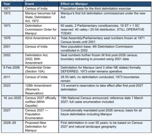
Manipur’s electoral constituencies were last formally delimited in 1973, under the Delimitation Commission constituted pursuant to the Delimitation Act, 1972. That exercise was based on the 1971 Census – a population enumeration now over fifty years old. The 60-seat State Assembly, the 19 ST- reserved seats, the 1 SC-reserved seat and the broad valley-hills distribution of constituencies all date from 1973. No subsequent delimitation has altered these fundamental boundaries.
A fourth Delimitation Commission was constituted in 2002 and worked on the basis of 2001 Census data. It produced draft proposals for Manipur, but by Presidential Order dated 8th February 2008 – citing security conditions under Section 10A of the Delimitation Act, 2002 – the delimitation exercise for Manipur (along with Assam, Arunachal Pradesh and Nagaland) was formally deferred. The 2001 Census-based delimitation for Manipur was never notified into force. The 1973 0rder remains operative.
This Working Paper advocates that the next delimitation of Manipur’s constituencies must be based exclusively on Census 2027 – India’s 16th National Census, officially notified on 16th June 2025, with a reference date of 1st March 2027. Census 2027 is the constitutionally mandated post-2026 census under the 84th Amendment (2002), and for the first time since 1931 will include full caste enumeration. Delimitation based on this data – and drawn on natural landscape geography rather than ethnic or political lines – will give Manipur the fair, durable and constitutionally sound electoral map it has waited more than half a century to receive.
- Historical Record of Delimitation in Manipur
2.1 The 1973 Delimitation – Operative Framework
The Delimitation Commission of India was constituted for the third time in 1972 under the Delimitation Act, 1972, following the 1971 Census. For Manipur – which had become a full State on 21st January 1972 under the North-Eastern Areas (Reorganisation) Act, 1971 – this commission undertook the first comprehensive delimitation of Assembly and Parliamentary constituencies. The key outcomes of the 1973 delimitation, which remain operative today, were:
- Total Assembly seats: 60
- Parliamentary constituencies: 2 (Inner Manipur and Outer Manipur)
- ST-reserved Assembly seats: 19 (covering all hill Assembly constituencies except Kangpokpi AC)
- SC-reserved Assembly seat: 1 (Sekmai AC)
- Valley-Hills seat distribution: 40 valley seats (Inner Manipur-dominated) and 20 hill seats (Outer Manipur dominated)
- District basis: 9 districts as they existed in 1973
These boundaries, ratios and reservations- determined over fifty years ago on the basis of 1971 population data – continue to govern representation in Manipur’s Legislative Assembly today.
2.2 The 42nd Amendment (1976)- Freezing the Seat Numbers
During the Emergency period, the 42nd Constitutional Amendment Act, 1976 froze the total number of Assembly and Parliamentary seats allocated to each state at the 1971 Census level until the year 2001. This meant that while the Delimitation Commission could redraw constituency boundaries within a state using subsequent census data, it could not change the total number of seats. This freeze is the reason why Manipur’s 60-seat Assembly has not changed in size since 1973.
2.3 The 2002 Delimitation Exercise – Attempted but Differed for Manipur
A fourth Delimitation Commission was constituted on 12th July 2002 under the Delimitation Act, 2002 (No. 33 of 2002), chaired by retired Supreme Court Justice Kuldip Singh. This commission worked on the basis of 2001 Census data to redraw constituency boundaries (though not alter total seat numbers) across 25 states and union territories. For most states, the new orders came into effect from 19th February 2008.
However, by four separate Presidential Orders all dated 8th February 2008 – issued under Section 10A of the Delimitation Act, 2002, on the ground that conditions in these states threatened India’s unity and integrity and posed a serious risk to peace and public order – the delimitation exercise was formally deferred for Assam, Arunachal Pradesh, Manipur and Nagaland. The 2001 Census-based delimitation order for Manipur was never brought into force. The 1973 delimitation order thus remains the operative legal framework governing Manipur’s constituency boundaries.
2.4 The 84th Amendment (2002) – Opening the Door for Census 2027
The 84th Constitutional Amendment Act, 2002 extended the freeze on total seat numbers to the first census to be taken after the year 2026. This is Census 2027. The cumulative constitutional position is therefore:
- The number of seats in each state’s Assembly and Parliament remains frozen at 1971 Census levels until Census 2027 data is published.
- The boundaries of constituencies within the states may be redrawn using census data (2001 data was used for most states in 2008, but not Manipur).
- Post-Census 2027, both the total number of seats and the boundaries of constituencies may be revised – making Census 2027 the most consequential census for Indian democracy since 1971.
- The 128th Constitutional Amendment Act, 2023 (Women’s Reservation Act) additionally mandates one-third reservation for women in legislative bodies, to take effect after the first delimitation exercise following Census 2027.
2.5 Chronological Summary
- Census 2027 – The Sole Valid Demographic Foundation
3.1 Why Census 2027 and No Other Dataset
A critical question arises: why must delimitation await Census 2027, and not proceed on the basis of the 2011 Census (the last published census), or on the basis of population projections? The answer is both constitutional and practical:
- Constitutional mandate: The 84th Amendment explicitly designates the first census after the year 2026 as the trigger for the next seat readjustment. That is Census 2027. No earlier or projected data can serve as constitutional substitute.
- Accuracy: Manipur’s 1973 delimitation was based on a population of approximately 10.7 lakh (1971). By 2011 the population had grown 28.55 lakh – a 167% increase. A projected or estimated figure for 2027 would introduce error; only actual enumerated Census 2027 data can give the Delimitation Commission a defensible and legally valid demographic base.
- Caste enumeration: Census 2027 will, for the first time since 1937, enumerate all castes and communities. For Manipur, this means the precise ST population of each hill district and sub-district will be known with accuracy unavailable in any previous census. This is essential for defensible reservation decisions.
- Women’s reservation: The 128th Amendment’s one-third women’s reservation in legislatures is specially tied to the delimitation exercise following Census 2027. Any earlier delimitation would not activate this historic right.
- Legal robustness: A delimitation order based on Census 2027 data will be legally unassailable. One based on projections or pre-2027 data risks challenge, though delimitation orders are ordinarily final.
3.2 Manipur’s Demographic Change Since 1971
The scale of demographic change since 1973 delimitation is staggering, and makes the case for urgency self-evident:
3.3 The Inequity of a 50-Year-Old Electoral Map
The consequence of Manipur’s 1973 delimitation remaining operative in 2026 is profound democratic inequity. Consider: a constituency that had 17,879 voters in 1971 now serves a population of approximately 47,597. But because all 60 constituencies have grown, the relative imbalance between valley and hill seats – determined in 1973 – has been magnified by differential growth rates. Hill district populations have grown at rates substantially higher than valley populations in some periods (need to be examine migration factors with fertility rate and age-group structure analysis comparing the different at decadal census), meaning the 40-seat valley / 20—seat hill ratio established in 1973 is demonstrably out of step with current demographic reality. Census 2027 will provide the data to correct this – definitively and constitutionally.
- Proportionate Increase in Seats Based on Census 2027
The 84th Amendment makes clear that from Census 2027 onwards, both the total number of seats and constituency boundaries may be revised. In Manipur’s case, an increase in the number of Assembly seats is both constitutionally permitted and demographically warranted. With a population that has grown by over 166% since 1973 delimitation, the current 60-seat House is proportionately more under-represented than almost any other Indian state. An indicative seat distribution framework (to be finalized using Census 2027 data) is presented below:
- The Natural Landscape Principle in Delimitation
5.1 Concept and Rationale
The natural landscape principle holds that constituency boundaries should follow geographically logical and physically permanent features – river basins, watershed ridges, hill ranges, and ecological zones – rather than boundaries drawn along community settlement patterns, administrative inheritance or political connivence. This approach offers decisive advantages:
- Permanence: Natural boundaries are immutable over the medium term, reducing the frequency and cost of future delimitation disputes.
- Neutrality: Natural landscape features have no ethnic, religious or community association, drastically reducing perceptions of gerrymandering.
- Contiguity: Constituencies defined by a river basin or a hill range naturally form compact, contiguous and administratively coherent units.
- Ecological governance: Representatives lied to a shared natural zone develop aligned interests in the water, forest, land and infrastructure.
- Legal durability: Boundaries derived from terrain maps and GIS data are harder to contest than those drawn along settlement lines.
5.2 Manipur’s Natural Landscape Zones
- Reserve Constituencies: ST and SC Seats
The reservation of Assembly seats for Scheduled Tribes and Scheduled Castes must be wholly determined by Census 2027 data. The following principles must govern:
- The number of ST-reserved seats must reflect the proportion of ST population in Manipur’s total Census 2027 enumerated population, applied to the total post-delimitation seat count.
- Full caste enumeration in Census 2027 will for the first time provide precise sub-tribal population data, enabling fair and defensible identification of ST-reserved constituencies across all landscape zones.
- ST-reserved seats must be distributed across all hill landscape zones proportionate to ST population in each zone – not assigned to specific communities or concentrated in politically convenient locations.
- No seat may be reserved for, or informally assigned to, a specific tribe, sub-tribe or community. Reservation is constitutional (ST/SC category) only, not community-specific.
- Women’s reservation (one-third of total seats) under the 128th Amendment will also take effect upon this delimitation – further underscoring the need for a comprehensive, Census 2027- based exercise.
- Parliamentary Constituency Reconfiguration
Manipur’s two Parliamentary constituencies – Inner Manipur and Outer Manipur – were also configured in the 1973 delimitation. The same principles apply: they must be redrawn using Census 2027 data and natural landscape boundaries. The current valley-hills binary which assigns the 32 valley seats to inner Manipur and the 28 (including 8 valley Assembly constituencies) seats to Outer Manipur has created a structural sense of depriving right to be a candidature to the citizen of the 8-seats of the valley constituencies. A landscape-based reconfiguration could better balance representation:
- Retaining 2 Parliamentary constituencies as the minimum, redrawn along natural landscape zone lines.
- Consideration of a third Parliamentary unreserved constituency (subject to the Delimitation Act framework) if Census 2027 data reveals that population has grown sufficiently to justify it.
- Safeguards Against Ethnic and Political Gerrymandering
- Census 2027 Data Lock: No data source other than officially published Census 2027 figures may be used. Projections, state estimates and NPR data are inadmissible.
- GIS Transparency: All maps, population overlays, draft orders and quota calculations must be published in open GIS format before finalization.
- Independent Expert Technical Panel: A statutory committee of geographers, hydrologists and GIS specialists – with no political or community affiliation – must validate all natural landscape boundary proposals.
- Community-Neutral Objection Filter: The Commission must formally reject any representation citing ethnic, community, religious or political representation grounds. Only population data and natural geography are admissible.
- Equal Population Standard: Deviation from the quota must not exceed 33% (as permitted under the Delimitation Act) and must be justified on natural geography grounds only.
- Multilingual Hearings: Public consultations must be conducted in Manipuri, and recognized dialects/languages of Manipur.
- Village-Level Publication: The final order must list every revenue village with its Census 2027 population figure, published in Manipuri and English.
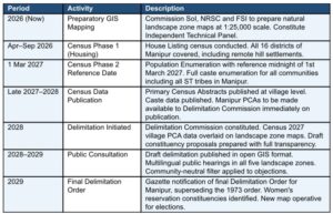
9. Process Roadmap and Timeline
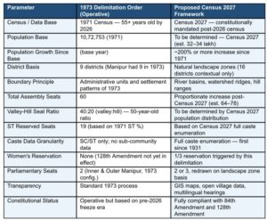
10. Comparative Analysis: 1973 Order vs Proposed Census 2027 Framework
- Process Roadmap and Timeline
- Comparative Analysis: 1973 Order vs Proposed Census 2027 Framework
- Recommendations
Formally acknowledge that the operative delimitation in Manipur dates from 1973 and based on the 1971 Census – not the 2007 notification (which was deferred and never brought into force). This correction is essential for any honest public discourse on delimitation.
- Commit publicly that the next delimitation of Manipur’s constituencies will be based exclusively on Census 2027 data, and that neither the 1971, 2001 nor the 2011 Census figures will serve as the demographic foundation for any new delimitation order.
- Commission preparatory natural landscape mapping immediately: Direct Soi, NRSC and FSI to prepare GIS-based natural landscape zone maps for Manipur at 1:25,000 scale, so that infrastructure is ready when Census 2027 data is available.
- Constitute an Independent Technical Panel of geographers, hydrologists and GIS specialists to advise the Delimitation Commission on the natural landscape methodology for Manipur.
- Ensure complete and accurate enumeration of all hill district settlements during Census 2027, deploying adequate bilingual enumerators in tribal languages to prevent historic patterns of undercounting.
- After Census 2027 data is published, increase Assembly seats proportionately to the population growth since the 1973 delimitation, distributing new seats across all natural landscape zones.
- Apply the women’s reservation requirement of the 128th Amendment in full, ensuring one-third of seats across all landscape zones and reservation categories are designated for women.
- Enforce the community-neutral objection filter strictly throughout the public consultation phase.
- Publish the entire delimitation process – map, data, draft orders, objections, hearing records and final order – in Manipuri and English, freely and digitally accessible.
- Conclusion
Manipur’s constituency boundaries are more than half a century old. They were drawn when the state’s population was barely 10.7 lakh, when it had only 9 districts, and when the demographic contour of its hills and valleys bore little resemblance to the present. The freeze imposed by successive constitutional amendments was a policy choice – understandable in its time – but it was never intended to last this long. For Manipur, uniquely, even the 2001 Census-based redrawing that was applied to most Indian states was deferred indefinitely.
Census 2027 changes everything. It is the constitutionally designated trigger for the next delimitation. It will count Manipur’s people as they actually are – in their hills and valleys, their numbers, their communities – for the first time in 55 years. And it will do so with a level of demographic detail, including full caste enumeration, that no previous census has achieved.
The natural landscape principle offers the methodology to translate that demographic reality into fair, stable and neutral constituency boundaries. Rivers do not vote. Ridgelines do not campaign. They are permanent, objective and community-blind. That is precisely why they should be the foundation of Manipur’s next electoral map.
This Working Paper is submitted in the conviction that Manipur’s people – in its valleys and on its hills, in its towns and its villages, across all its communities – deserve an electoral map that represents who they are today, not who they were in 1971.
Annexure A: Key Legal and Official References
- Constitution of India: Articles 82, 170, 330, 332 – Delimitation and Reservation of Seats
- 42nd Constitutional Amendment Act, 1976 – Freeze on seat numbers till 2001
- 84th Constitutional Amendment Act, 2002 – Extension of Freeze to first post-2026 census
- 128th Constitutional Amendment Act, 2023 -Women’s reservation (one-third), operative after first post-2027 delimitation
- Delimitation Act, 1972 (Act No. 76 of 1972) – Basis of the operative 1973 delimitation
- Delimitation Act, 2002 (Act No. 33 of 2002)
- Presidential Order dated 8th February 2008 [S.O. 283€ and related orders] – Deferment of delimitation for Manipur, Assam, Arunachal Pradesh and Nagaland under Section 10A of the Delimitation Act, 2002
- Census Act, 1948 and Census Rules, 1990
- Gazette Notification No. S.O. 2677€, Ministry of Home Affairs, dated 16th June 2025 – Official notification of Census 2027
- Delimitation Commission Order for Manipur, 1973 – THE OPERATIVE DELIMITATION ORDER (under Delimitation Act, 1972)
- Census of India, 1971 -Primary Census Abstract, Manipur
- Census of India, 2011 -Primary Census Abstract, Manipur (Series 15) [for historical reference]
- North-Eastern Areas (Reorganisation) Act, 1971 – Manipur attained Statehood 21st January 1972
- Manipur (Hill Areas) District Council Act, 1971
Annexure B: Glossary of Key Terms
- Delimitation: The legal process of redrawing the boundaries of electoral constituencies and, where permitted, adjusting the number of seats, conducted by the Delimitation Commission of India after each decennial census.
- 1973 Delimitation Order: The operative delimitation order for Manipur, issued under the Delimitation Act, 1972 on the basis of the 1971 Census. Currently governs all Assembly and Parliamentary constituency boundaries in the state.
- Section 10A Deferment: The legal mechanism under Section 10A of the Delimitation Act, 2002 by which the 2001 Census-based delimitation was deferred for Manipur by Presidential Order dated 8th February 2008.
- Census 2027: India’s 16th National Census, officially notified on 16th June 2025, with population enumeration reference date of 1st March 2027. First census after 2026 as required by the 84th
- Natural Landscape Zone: A geographic region defined by physical terrain features – river basins, hill ranges, watershed boundaries and ecological zones – used as the boundary framework for constituency delimitation.
- Quota: The average population per constituency = Total State Population + Total Seats. The constitutional standard each constituency must approximate.
- 84th Amendment: The 84th Constitutional Amendment Act, 2002, which froze the total number of Assembly and Parliamentary seats per state until the first census after 2026 (Census 2027).
- 128th Amendment: The 128th Constitutional Amendment Act, 2023 (Women’s Reservation Act), mandating one-third reservation for women in Lok Sabha and State Assemblies, operative after the first delimitation following Census 2027.
- Caste Enumeration: Systematic counting of population by caste/community category – included in Census 2027 for the first time since 1931.
GIS (Geographic Information System): Software-based spatial data management and mapping. Used for transparent, reproducible and available and verifiable constituency boundary delimitation.
The writer is a former Member of Parliament and a former Union Minister of State External Affairs and Education, Government of India.

Working Paper: Delimitation Based on Census 2027 will be an Alternative Framework Grounded in Natural Landscape Geography 2026
DR. RAJKUMAR RANJAN SINGH
HISTORICAL CORRECTION: The 2007 notification was based on the 2001 Census but was formally DEFERED and never brought into force for Manipur by Presidential Order dated 8th February 2008 (under Section 10A of the Delimitation Act, 2002), citing security conditions. The constituency boundaries currently operative in Manipur derive from the delimitation exercise conducted in 1973 under the Delimitation Act, 1972 – based on 1971 Census. The current 60-seat Assembly and the 19-ST/ 1-SC reserved seat configuration date from that 1973 exercise. Manipur’s electoral map is therefore over FIFTY YEARS OLD and rests on a census that is now more than FIVE DECADES out of date. This makes the case for a fresh, Census 2027 -based delimitation not merely desirable but constitutionally and democratically imperative.
STATUS NOTE: This Working Paper proposes a new delimitation framework for Manipur that: (i) recognizes the 1973 delimitation (based on 1971 Census) as the actual operative boundary regime; (ii) corrects the record regarding the deferred 2007 notification; (iii) uses Census 2027 – the 16th National Census officially notified by the Ministry of Home Affairs on 16th June 2025 – as the sole valid demographic foundation; and (iv) advocates delimitation grounded in natural landscape geography rather than ethnic, community or political lines.
1.Executive Summary
Manipur’s electoral constituencies were last formally delimited in 1973, under the Delimitation Commission constituted pursuant to the Delimitation Act, 1972. That exercise was based on the 1971 Census – a population enumeration now over fifty years old. The 60-seat State Assembly, the 19 ST- reserved seats, the 1 SC-reserved seat and the broad valley-hills distribution of constituencies all date from 1973. No subsequent delimitation has altered these fundamental boundaries.
A fourth Delimitation Commission was constituted in 2002 and worked on the basis of 2001 Census data. It produced draft proposals for Manipur, but by Presidential Order dated 8th February 2008 – citing security conditions under Section 10A of the Delimitation Act, 2002 – the delimitation exercise for Manipur (along with Assam, Arunachal Pradesh and Nagaland) was formally deferred. The 2001 Census-based delimitation for Manipur was never notified into force. The 1973 0rder remains operative.
This Working Paper advocates that the next delimitation of Manipur’s constituencies must be based exclusively on Census 2027 – India’s 16th National Census, officially notified on 16th June 2025, with a reference date of 1st March 2027. Census 2027 is the constitutionally mandated post-2026 census under the 84th Amendment (2002), and for the first time since 1931 will include full caste enumeration. Delimitation based on this data – and drawn on natural landscape geography rather than ethnic or political lines – will give Manipur the fair, durable and constitutionally sound electoral map it has waited more than half a century to receive.
2.1 The 1973 Delimitation – Operative Framework
The Delimitation Commission of India was constituted for the third time in 1972 under the Delimitation Act, 1972, following the 1971 Census. For Manipur – which had become a full State on 21st January 1972 under the North-Eastern Areas (Reorganisation) Act, 1971 – this commission undertook the first comprehensive delimitation of Assembly and Parliamentary constituencies. The key outcomes of the 1973 delimitation, which remain operative today, were:
These boundaries, ratios and reservations- determined over fifty years ago on the basis of 1971 population data – continue to govern representation in Manipur’s Legislative Assembly today.
2.2 The 42nd Amendment (1976)- Freezing the Seat Numbers
During the Emergency period, the 42nd Constitutional Amendment Act, 1976 froze the total number of Assembly and Parliamentary seats allocated to each state at the 1971 Census level until the year 2001. This meant that while the Delimitation Commission could redraw constituency boundaries within a state using subsequent census data, it could not change the total number of seats. This freeze is the reason why Manipur’s 60-seat Assembly has not changed in size since 1973.
2.3 The 2002 Delimitation Exercise – Attempted but Differed for Manipur
A fourth Delimitation Commission was constituted on 12th July 2002 under the Delimitation Act, 2002 (No. 33 of 2002), chaired by retired Supreme Court Justice Kuldip Singh. This commission worked on the basis of 2001 Census data to redraw constituency boundaries (though not alter total seat numbers) across 25 states and union territories. For most states, the new orders came into effect from 19th February 2008.
However, by four separate Presidential Orders all dated 8th February 2008 – issued under Section 10A of the Delimitation Act, 2002, on the ground that conditions in these states threatened India’s unity and integrity and posed a serious risk to peace and public order – the delimitation exercise was formally deferred for Assam, Arunachal Pradesh, Manipur and Nagaland. The 2001 Census-based delimitation order for Manipur was never brought into force. The 1973 delimitation order thus remains the operative legal framework governing Manipur’s constituency boundaries.
2.4 The 84th Amendment (2002) – Opening the Door for Census 2027
The 84th Constitutional Amendment Act, 2002 extended the freeze on total seat numbers to the first census to be taken after the year 2026. This is Census 2027. The cumulative constitutional position is therefore:
2.5 Chronological Summary
3.1 Why Census 2027 and No Other Dataset
A critical question arises: why must delimitation await Census 2027, and not proceed on the basis of the 2011 Census (the last published census), or on the basis of population projections? The answer is both constitutional and practical:
3.2 Manipur’s Demographic Change Since 1971
The scale of demographic change since 1973 delimitation is staggering, and makes the case for urgency self-evident:
3.3 The Inequity of a 50-Year-Old Electoral Map
The consequence of Manipur’s 1973 delimitation remaining operative in 2026 is profound democratic inequity. Consider: a constituency that had 17,879 voters in 1971 now serves a population of approximately 47,597. But because all 60 constituencies have grown, the relative imbalance between valley and hill seats – determined in 1973 – has been magnified by differential growth rates. Hill district populations have grown at rates substantially higher than valley populations in some periods (need to be examine migration factors with fertility rate and age-group structure analysis comparing the different at decadal census), meaning the 40-seat valley / 20—seat hill ratio established in 1973 is demonstrably out of step with current demographic reality. Census 2027 will provide the data to correct this – definitively and constitutionally.
The 84th Amendment makes clear that from Census 2027 onwards, both the total number of seats and constituency boundaries may be revised. In Manipur’s case, an increase in the number of Assembly seats is both constitutionally permitted and demographically warranted. With a population that has grown by over 166% since 1973 delimitation, the current 60-seat House is proportionately more under-represented than almost any other Indian state. An indicative seat distribution framework (to be finalized using Census 2027 data) is presented below:
5.1 Concept and Rationale
The natural landscape principle holds that constituency boundaries should follow geographically logical and physically permanent features – river basins, watershed ridges, hill ranges, and ecological zones – rather than boundaries drawn along community settlement patterns, administrative inheritance or political connivence. This approach offers decisive advantages:
5.2 Manipur’s Natural Landscape Zones
The reservation of Assembly seats for Scheduled Tribes and Scheduled Castes must be wholly determined by Census 2027 data. The following principles must govern:
Manipur’s two Parliamentary constituencies – Inner Manipur and Outer Manipur – were also configured in the 1973 delimitation. The same principles apply: they must be redrawn using Census 2027 data and natural landscape boundaries. The current valley-hills binary which assigns the 32 valley seats to inner Manipur and the 28 (including 8 valley Assembly constituencies) seats to Outer Manipur has created a structural sense of depriving right to be a candidature to the citizen of the 8-seats of the valley constituencies. A landscape-based reconfiguration could better balance representation:
9. Process Roadmap and Timeline
10. Comparative Analysis: 1973 Order vs Proposed Census 2027 Framework
Formally acknowledge that the operative delimitation in Manipur dates from 1973 and based on the 1971 Census – not the 2007 notification (which was deferred and never brought into force). This correction is essential for any honest public discourse on delimitation.
Manipur’s constituency boundaries are more than half a century old. They were drawn when the state’s population was barely 10.7 lakh, when it had only 9 districts, and when the demographic contour of its hills and valleys bore little resemblance to the present. The freeze imposed by successive constitutional amendments was a policy choice – understandable in its time – but it was never intended to last this long. For Manipur, uniquely, even the 2001 Census-based redrawing that was applied to most Indian states was deferred indefinitely.
Census 2027 changes everything. It is the constitutionally designated trigger for the next delimitation. It will count Manipur’s people as they actually are – in their hills and valleys, their numbers, their communities – for the first time in 55 years. And it will do so with a level of demographic detail, including full caste enumeration, that no previous census has achieved.
The natural landscape principle offers the methodology to translate that demographic reality into fair, stable and neutral constituency boundaries. Rivers do not vote. Ridgelines do not campaign. They are permanent, objective and community-blind. That is precisely why they should be the foundation of Manipur’s next electoral map.
This Working Paper is submitted in the conviction that Manipur’s people – in its valleys and on its hills, in its towns and its villages, across all its communities – deserve an electoral map that represents who they are today, not who they were in 1971.
Annexure A: Key Legal and Official References
Annexure B: Glossary of Key Terms
GIS (Geographic Information System): Software-based spatial data management and mapping. Used for transparent, reproducible and available and verifiable constituency boundary delimitation.
The writer is a former Member of Parliament and a former Union Minister of State External Affairs and Education, Government of India.
Also Read
Boong: The Silent Scream that Exposes an Invisible Oppressive Feudal Patriarchal Order
The Manipuri movie Boong written and directed by Laxmipriya Devi and produced by Farhan Akhtar, was understandably celebrated in Manipur for its cinematic brilliance, and
The War That Never Ended: Why Thokchom Borun’s Battlefield Could Become One of India’s Most Striking Anti-War Documentaries
Waari Singbul Network “At the beginning, I was completely lost. I did not know how to approach the story,” — Borun Thokchom As the curtains
Sound of melody weaving
Heard the sound beautifully melodious — tad- tad tad- tad Spindles in fingertips eye, inherent legacy in mind, It weaves not for money, but for
Kamjong Border Attacks Reveal the Expanding Transnational and Territorial Dimensions of the Manipur Crisis
The coordinated attacks on Choro, Namlee, and Wanglee villages along the Indo–Myanmar border in Manipur’s Kamjong district on May 7, 2026 are not isolated episodes
Rabindranath Tagore: Celestial Architect of Universal Humanism, Aesthetic Pedagogy and Spiritual Civilization
Introduction: Tagore as a Civilizational Luminary beyond Time Few personalities in the annals of world civilization possess the astonishing universality, luminous versatility and spiritual grandeur