No doubt, natural disasters are known to strike without warning and often we are caught on the wrong foot during their occurence. Yet, a right approach, especially when working in terrains known to be geologically fragile, can go a long way in averting such incidents that are sometimes triggerred by man’s reckless actions.
The Marangching massive landslide at Makhuam village in Manipur’s Noney district where Tupul Railway yard is being constructed is said to be one of the worst such disasters in recent times in the country. Manipur recorded at least 20 major landslides since 2014 and this high number ought to have been factored in while undertaking the construction works.
In most cases, the government and it officials and even public leaders cited heavy rainfalls and exploitation of forest by the villagers as the only reasons of landslides as if the construction works being carried out aimed at development has nothing to do with the landslides occurred in Manipur.
Now, some pertinent questions need to be asked. Is the Marangching landslide a natural disaster or man-made disaster? Is it construction-related landslide? Is the Railways Ministry not responsible for the landslide?
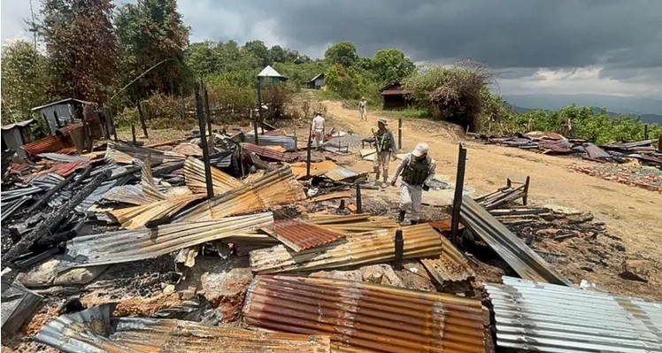
The Marangching landslide that occurred 30 minutes past midnight on the intervening night of June 29 and 30 trapping 79 (earlier reported to be 81) people including 43 security personnel is the worst landslide in Manipur in recent times. The Marangching landslide has destroyed the Tupul Railway yard construction and blocked the Ijei River. Only 18 persons have been rescued till now and the remaining others are believed to be killed of which 54 dead bodies have been recovered till the time of writing this story and seven bodies are still missing.
The affected area is part of the ongoing 110-Km Jiribam-Tupul-Imphal railway project that is being constructed to bring Maniour’s capital Imphal to the country’s railway map where the government plans to extend the line up to the border town of Moreh and connect to Myanmar and other Southeast Asian countries after connecting Imphal to the rail network by 2024.
More unfortunately, the Marangching landside debris also created a dam-like barrier blocking the flow of the Ijai River hampering the rescue operations.
After the landslide, another question many people including experts and enviromentalists reiterate – Was there not Environmental Impact Assessment (EIA) before taking up the construction of railways? Even if it was done, many suspect that the Environmental Impact Assessment on the Jiribam-Tupul-Imphal railway project was not done systematically and scientifically but rather to allow the railways construction project to go ahead without any obstructions. Or even if it was done properly, there is possibility of not executing properly the recommendations of the Environmental Impact Assessment.
The suspicion of the people is substantiated by the comments and statements from officials, experts and reports about the Marangching landslide.
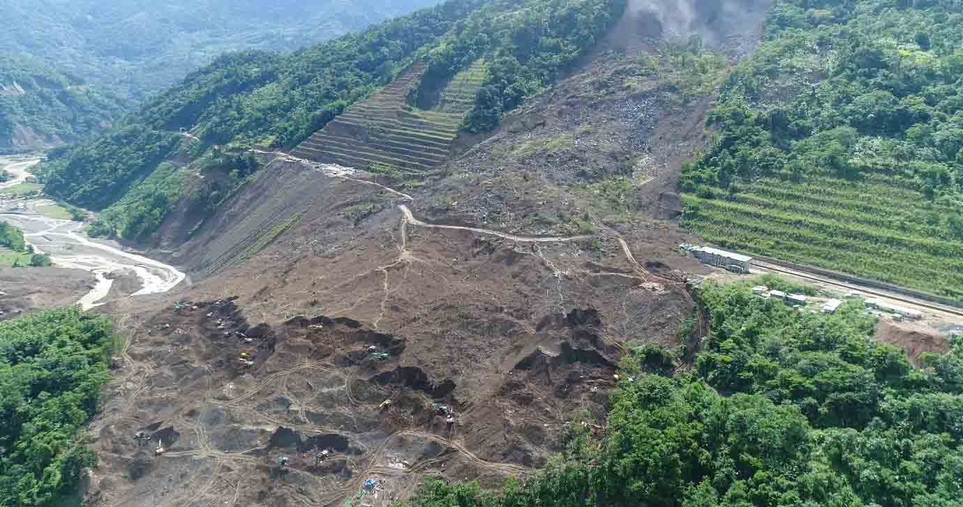
Reports have quoted the Geological Survey of India (GSI) as saying in its first technical report that extensive cutting of a steep slope to build a railway station in Manipur’s Noney district resulted in the massive landslide of Marangching on June 29 and 30 intervening night. The landslide, owing to the unscientific excavation came down on an under-construction Tupul Railway yard, a barrack of 107 Territorial Army, one camp of Northern Frontier Railways, and a labour camp.
The Railway formation at 570 m msl height was developed for the yard, railway station and open cut for the railway track. The slide triggered from the crest of a hill and debris slided in the Ijai river bed. An area of 31 hectares approximately was affected by the massive landslide in which the open cuts and major part of the railway yard was devastated along with casualties.
Notably, a team of experts consisting of Prof Arun Kumar and Dr. Manichandra Sanoujam, both of Department of Earth Sciences, Manipur University; Dr. Thingujam Dolendro of Geo-Consult India; Moirangthem Jagajit of Computer Gallery Imphal; besides Dr. N Sanamacha Singh, SK Gainaimei and RK Bikramjit all three from the Directorate of Environment and Climate Change, Government of Manipur, surveyed the landslide area.
They had visited the landslide affected village on July 5 along with Dr. R. K. Ranjan, Union Minister of State for External Affairs and Education. The team submitted the survey report to the Union Minister of State for External Affairs and Education Dr. R.K. Ranjan, who then submitted the same to Union Minister of Railways Ashwini Vaishnaw and Manipur Chief Minister Nongthombam Biren.
The survey report says, “Geologically, non-resistant lithologies (shale inter-bedded with mudstone, siltstone and sandstone) of Barail Group exposed in the study area after the modification of the slope geometry that impedes the mountain’s ability to resist the existing gravitational force may become one of the causes of mass wasting/landsliding.”
The two contrasting combinations of litho units in the western Manipur as well as in the study area seem to be one of the causes for slope instability, the report said.
Manipur state is included in the High Seismic Hazard (Zone V, Seismic Zonation Map of India) and hence, the micro seismicity is active besides a large earthquake of 2016 (M6.7) which is near to the recent landslide area. Based on the fault plane solutions (Global CMT Project) of earthquake data, the principal P-axis is towards north, indicating the compression direction, resulting in the extension along east-west. The resulting creeping of micro deformation towards the western slopes of the terrain including the recent landslide area is aligned with the principal T-axis. It is also seems to be one of the triggering factors for the hazard as few minor cracks are observed in the cut slopes of the railway yard, the survey report said.
Changing in the land use patterns on the top of hill like deforestation, Jhum cultivation, banana cultivation, which also accelerated the soil erosion process and might also be the secondary factors for the recent landslides, the survey report added.
Following the survey, the team has recommended carrying out a reassessment of Slope stability (Factor of safety) analysis for open cuts and yards of the Jiribam Tupul Railway Line.
To prevent such eventuality in future, the team made some recommendations based on their studies. Some of the recommendations are: Reassessment of Slope stability (Factor of safety) Analysis for open cuts and yards of the Jiribam Tupul Railway Line; Regular Drone survey and monitoring to detect the mass movement along the open cuts and yards as well as beyond railway land boundary before and after monsoon season without a significant failure event, the detection of subtle slope movements across a short survey interval using DEM-differencing will likely prove challenging to identify; Installation of automatic weather stations for monitoring of weather data at major Railway Station sites from Jiribam to Tupul (precipitation and soil moisture); Installation of slope failure monitoring with web enabled equipment (Borehole extensometers, optical targets, tilt meters, piezometer, crack meter, soil moisture meter at a depth of 5-10 meters) at open cuts and yards; and Geology of the area cannot be changed, however, the innovation of new and emerging technologies and ideas will mitigate these disastrous situations.
The report also recommended for engaging people who are working in the relevant fields and familiar with the terrain and geological conditions of the area at the time implementing the above-mentioned recommendations.
The survey report says, the Jiribam -Tupul-Imphal Railway Project is progressing well and the recent landslide has affected the railway formations in the proposed Tupul Station yard. Since, it will be one of the major life-line for the state in order to transport goods and passengers from rest of the country to the state, therefore, considering the success and longevity of the ongoing project for several decades, it is necessary to adopt the regulatory monitoring of the vulnerable slopes along the railway line where the cut portion and yards are exposed.
Moreover, development policy and planning must be guided by principles that take cognizance of the need to give due respect to the natural environment including the geology of a given area. Any ham-handed approach that seeks to facilitate development by riding roughshod over Nature is bound to trigger a severe backlash. Apparently, the massive construction works undertaken in the area required massive destruction of forested hills and clearly those were not done scientifically, expecially in maintaining the natural hill slope gradients.
Even the Union Ministry of Environment and Forest acknowledged that the disasters were ‘anthropologically-induced’ and this should have made the development interventions preceeded by a thourough scientific assessment. The Ministry identified the causes of lanslides in Manipur as “a result of modification of slopes for construction, widening of road, quarrying for construction materials, fragile lithography, complex geologiocal structures and heavy rainfall.”
The Marangching massive landslide, the worst disaster in recent time in Manipur should be considered as a national disaster as Jiribam-Tupul-Imphal Railway project is a national project and also it should be a wake-up call for the government so that the genuine concerns of the environment are adequately addressed before going ahead with the development project. The Marangching massive landslide should be investigated and responsibilites be fixed. Further Railways construction should be stopped not because it is affected by the landslide but because evaluation into the nature and level of compliance with the Environmental Principles taking into account the ground realities should be conducted afresh before going ahead further.

Senior Editor: Imphal Review of Arts and Politics