


Cyclone Remal which devastated Bangladesh, Bengal and the Northeast states is once again a grim reminder that climate change is for real and thereby it is prudent for everybody to acknowledge the necessity of climate action, and join the campaign in each’s capacity. Very broadly, this action has to be in two distinctly separate approaches. This is important, for often the two tend to be conflated in ordinary parlance and understanding, causing confusion to the entirety of the issue.
Of the two, one has to do with climate change mitigation actions, and the goals for this will necessarily have to be seen in the long term, and the approach too will have to be in tandem with measures agreed upon on the broader global canvas. The time worn slogan, “Think Global, Act Local”, defines this responsibility perfectly.
Nobody can hope to reverse climate change on their own, and it will have to be by a joint global effort. It is in acknowledgment of this that there are periodic global climate summits to discuss and evolve consensual global mitigation strategies. Some of the alerts already flagged by these summits include controlling greenhouse gas emission, planting trees, avoiding deforestation, prudence in use of artificial fertilisers and pesticides etc., and it is everybody’s responsibility to contribute in their own ways towards these global objectives. These contributions too would have to be location specific. If deforestation is an issue in some cases, it could be carbon emission activities in others etc.
Today we are also seeing a convergence of goals of different fields of human activities and professions on the matter. Even the theme this year of the World Press Freedom Day which falls on May 3, is “A Press for the Planet: Journalism in the face of the Environmental Crisis”, with an added clause that the objective should be to counter motivated campaigns by climate change deniers on the basis of false scientific data and interpretations.
But this is a larger debate and for now let me not delve deeper into it, particularly because we now have the second issue at hand on an emergency basis – that of coping with the fallout of climate change. After seeing the unpredictable rampage of extreme weather such as Cyclone Remal, it should no longer need further elaboration the threat Climate Change can bring to everybody. And since extreme climate events are now a reality and can only get worse, it is imperative for all to evolve coping mechanisms so as to the survive these changes while the longer-term fight to reverse these trends continues on other planes.
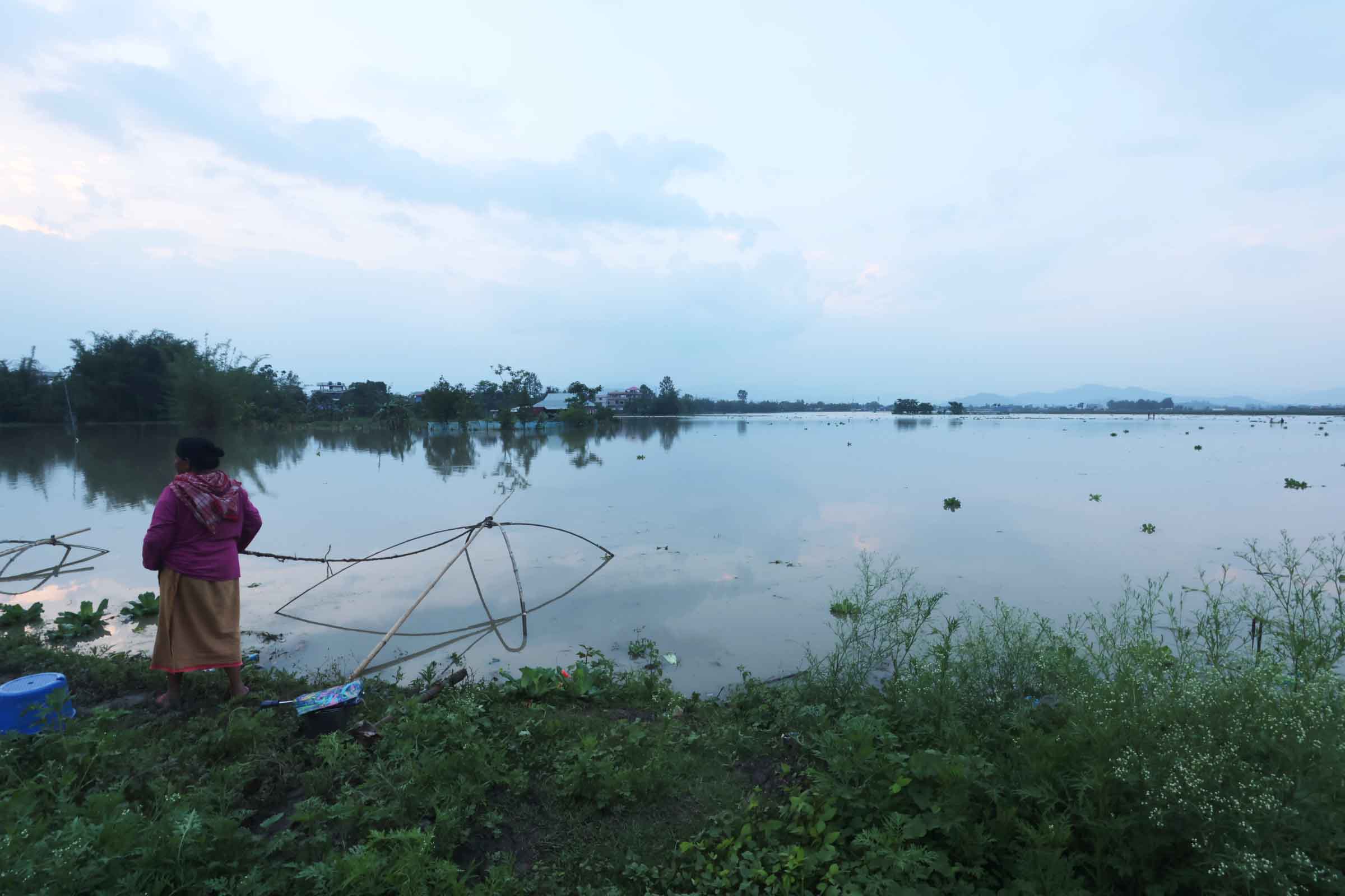
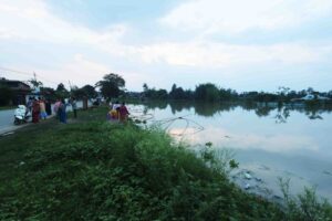
For a state like Manipur, falling within the tropical belt, therefore receiving liberal share of annual rainfall, there can be no gainsaying that one of the Climate Change fallouts which is set to become its challenge will be in the area of water management. This can either come as drought or else floods. Even before the devastations of Cyclone Remal, this had become increasingly evident even in the rainfall pattern of the last decade. Last year, a drought like situation had led to extensive crop failure and this year, a pre-monsoon cyclone is causing immense suffering including loss of three lives in the state, but 38 in the entire Northeast.
Under the circumstance, what is it that the state should do by way of coping measure. Let us take the case of floods in the valley and landslides in the hills, for these are currently the most immediate crises. In the hills, it is constant deforestation and exposure of the soil to the onslaught of rains loosening its adhesion to the sloped terrain, ultimately leading to landslides and mudslides. Had these soil been allowed to retain their green cover this problem would have been minimised. The floods in the valley are also related to the hillsides losing their green cover. Fallout of environment degradation knows no political or ethnic boundaries therefore everybody has a stake in keeping the environment healthy, and consequently, it is also legitimate for everybody to be concerned or outraged by deforestation anywhere, not just within the state boundaries, but even in distant places like the Amazon rain forest.
In the valley area, the immediate danger is posed by the behaviour of its rivers, as we have seen. Rivers can overflow their banks, and in the worse scenarios, break and burst their banks at pressure points. The principle of centrifugal force should make it clear to a great extent that these pressure points would normally be where the river bends.
Away from the rivers, there is also an added problem caused by clogged and non-functional drainage systems in the towns and other settlement areas. These two again should not be conflated to be one, and either needs to be tackled differently. The first is a natural process exacerbated by Climate Change, and the second is yet another stark demonstration of administrative failure, dishonesty and lack of vision.
If floods along the western bank of the Imphal River in Imphal West area was on account of a breach of the river bank in this sector, the same reason cannot be attributed to floods at Andro Parking, Kwakeitel areas etc. These later areas were flooded because there was nowhere rain water could drain away. If the administration can be absolved of the earlier kinds of floods, this cannot be so for the latter.
Of the second case, the relevant government departments such as PWD, Town Planning, IFCD, PHED etc should be made accountable. They should also be made to pull up their socks to do the needful in designing and maintaining a functional drainage system in all settlement areas.
It is ironic that in the pre-modern era, the kings of Manipur had greater vision in this regards, evidenced by the network of khongbans (traditional drainage system) which flanked practically every road and by-lanes (Leiraks), leading to the many wetlands (Pats). Even in the Imphal area, there were once many of these wetlands such as Lamphelpat, Porompat, Keishampat, Sangaipat, Akampat etc. These acted as natural reservoirs where flood waters drained into via the Kongbans in the rainy seasons so that residential areas and paddy fields remained spared of flooding. When the rainy seasons receded, these reservoirs then would release their waters, either to dry areas or else back into the rivers.
Most of these wetlands have now been reclaimed, either as real estate in settlement areas or else as paddy fields in rural areas. It must be conceded there is a degree of inevitability about land reclamations considering the growth of population and expansion of administrative infrastructures, such as hospitals and other public institutions, but in planning these new infrastructures serious thoughts ought to have been given to make alternate reservoirs with the same holding capacities as the natural ones.
For instance, if part of Porompat were to be reclaimed for JNIMS and Doordarshan, the remaining parts should have been dug deeper to compensate for the loss of storage capacity of the natural wetland. If not, the water which were originally flowing into these natural reservoirs before they were tampered, would have to flow elsewhere, including residential areas or any other relatively low-lying areas.
In Lamphelpat, for the first time, this is being done to create a deeper artificial reservoir, and it will be interesting to study if the reason for habitation areas at Lamphelpat area being spared of flood waters during Cyclone Remal had anything to do with this new artificial reservoir. It is also interesting that wherever these pats remained intact, such as Yaralpat, or partially functional ones such as Sangaipat, residential areas around them were spared of flood waters this time.
The other equally important challenge is, in times of similar cyclones such as Remal, how must Manipur manage its rivers. Again, it is ironic that in the olden feudal days, this was done much more effectively by the kings of yore, as evidenced by the accounts of turel marin tengba (dredging the river beds) in the royal chronicle Cheitharol Kumbaba. In this, communities are periodically mobilised as voluntary work force to dredge rivers during the dry seasons. This is in acknowledgment of the natural phenomenon of silting.
This silting process must have been slower in those days when the forest covers in the hills were still intact and much more primal than now in the face of massive deforestation for varying reasons. This dredging practice could be revived for instance as part of the already existing MGNREGS schemes, augmented and supplemented by direct interventions under other programmes of the government. The village communities can also sell the dredged soil for some extra earnings too.
Another intervention strategy which must be given a serious thought is the prospect of linking all or at least the major rivers that flow into the Imphal valley. Considering they are all in a relatively compact area, and that none of them are overwhelmingly large, this should not be an impossible task. If canals linked the major rivers at different points along their routes, not only can water be shared when needed, but in times of flood emergencies water could be siphoned away from swollen rivers to others flowing below danger levels. Since the catchment areas of all these rivers are different, most of the time all these rivers should flow at different levels. If it rains heavily on the Shirui hillside or the Tungjoy crest, Thoubal River would be swollen, likewise if Kangchup and Kounu receives more rain, it will be Namul River which gets swollen, if it is the Koubru hillside, it will be Imphal River’s turn to be swollen, or if it is the Lakhamai-Khongdei Khuman-Ngamju-Tingson crest, it will be the Iril River which takes the water.
In the present emergency brought by Cyclone Remal for instance, Iril River and Kongba Rivers flowed relatively low, so if some of the waters from Imphal River which ultimately breached its banks to cause devastating floods, could have been diverted to Iril and Kongba, maybe the Imphal River breach at Khabam area could have been prevented.

Editor, Imphal Review of Arts and Politics and author