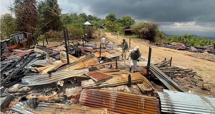
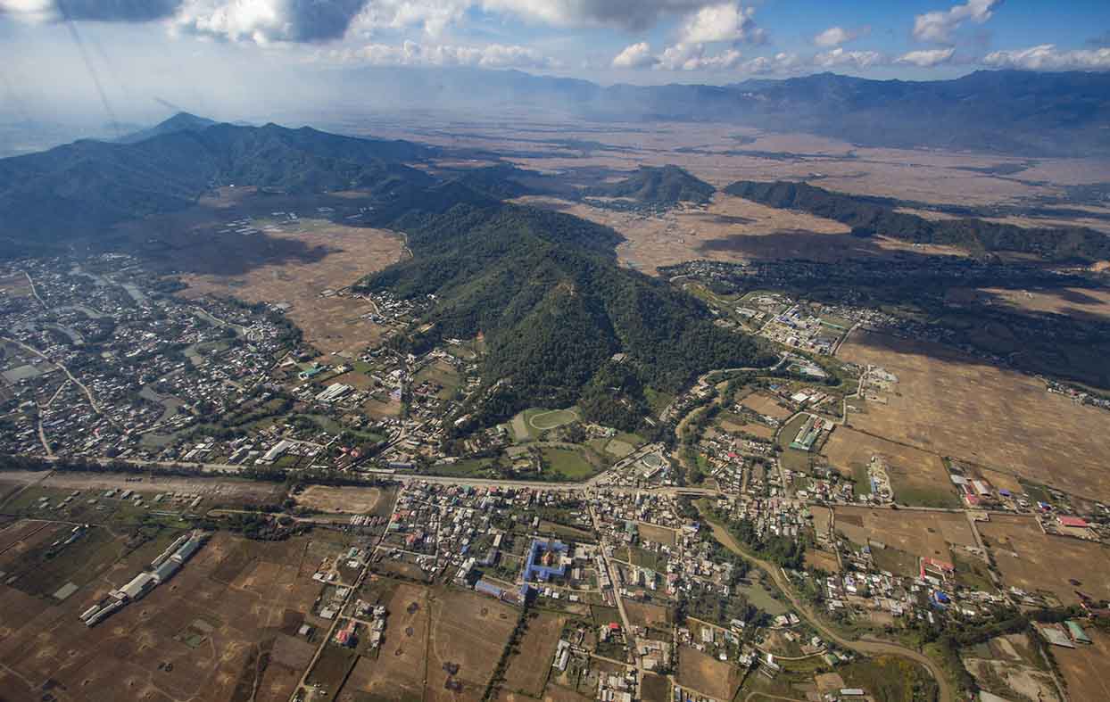
Nongmaijing incident
Another world environment day, June 5, just passed by. Unfortunately, there were some unsavoury incidents during a tree plantation drive on the day when a village in the foothills of Nongmaijing hill ranges, Nongmaipal village, objected to a ceremonial tree plantation drive in what the villagers claimed was their village precinct. On record however, it later turned out the area the tree plantation was to take place had been declared a reserved forest with the consent of villages in the vicinity. The area in question was also an uninhabited strip of forest at the time it was declared as reserved under the Indian Forest Act 1927, but the particular village which objected to the recent tree plantation had relocated itself within this reserved forest.
Unfortunately, the incident acquired a communal visage for the village in question was a Kuki village, and those who went to the forest land to plant trees were forest department officials accompanied by people largely from the adjacent Meitei villages in the plains, and the narrative fitted into Manipur’s familiar hill-valley binary, so eagerly nurtured by many different vested interests.
Phayeng incident
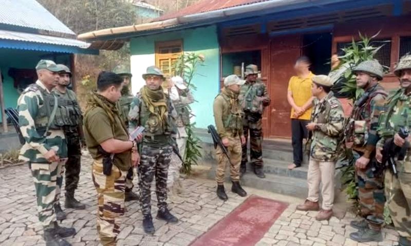
Two days after this incident, this binary manifested in a different way at another place, Phayeng village, again in the foothills of the Kangchup hills which is part of the Kounu ranges, but more towards the plains. There is a well-maintained forest strip here, sacred to the Chakpa Meitei community of Phayeng. The Manipur Forest Department tried to put up a signboard to denote this community forest is also a reserved forest under the same Indian Forest Act 1927, but the villagers vehemently protested, and the protest is on account of the indication in the signpost that this is part of the Kangpokpi district.
Ordinarily any piece of land belonging to one district or other, or spreading across two or more districts should not have mattered at all, except for the inconveniences it may likely cause to administrators who would be left uncertain while deciding jurisdictions, but in Manipur this outlook has been overturned, for in matters of land revenue administration, the state follows two laws, one for the hills and the other for the Imphal valley.
This qualification as “Imphal” valley is essential, for there are several other valleys in the state, but the rest are considered hills. And the peculiar thing about this is, while the law followed in the Imphal valley is universal and everybody can have its benefits, the law for the hills is exclusionary, when it comes especially to the valley dwellers, the Meiteis. So what the Phayeng villagers intuitively feared is, if their sacred grove is allowed to be included in Kangpokpi district, they may become excluded from reaping the spiritual and material succour they have always drawn from the forest, believing Kangpokpi is also an exclusionary hill district. This belief however is only a half-truth, for Kangpokpi, which was once Sadar Hills, is not exactly reserved exclusively for the hill tribes which is why even Nepalis can vote and contest its Assembly seat, not just live there.
FPIC important
Of the former incident, there are two things to be noted. One, all civic programmes in future, whether it is initiated by the government or civil society, should make the effort to enlist all stakeholders as participants by the well-known principle of Free Prior Informed Consent, or FPIC as it also known amongst development workers. If the village which protested were also to be made part of the tree plantation campaign on the mutual consent and conviction that this would ultimately benefit all, including themselves, and that this was also in view of contributing each individual’s mite to the larger cause of humanity of saving planet earth, probably all the ugliness would have been saved.
Proliferating villages
The other and more immediate problem for the state to tackle, again has to do with land revenue administration. How can an administration ever be effective if villages are allowed to proliferate or shift at will? How can an administration size up its resources and responsibilities if it is uncertain where its populations are located? These constant shifts of population among certain communities is undoubtedly determined much by unstable traditional economy, therefore it is time for the administration to introduce suitable alternative economic activities that would make populations incline towards a more sedentary lifestyle. As it is, it is visibly difficult for the administration to reach roads, schools and other infrastructures to all corners of the state, but if its villages are also on the move constantly, the task would understandably become impossible. In the hills, we know that Nagas are generally sedentary, but Kukis are less so. In the valley, where modern land revenue laws are followed, undocumented shifts of population is ruled out, for if anybody shifts even a few feet from the small plot he or she owns, either towards another individual’s land or else government public land, he would become an encroacher and deserve penalty. Some still do it stealthily, and sometimes in connivance with revenue officials, but this is nonetheless illegal. This is also why the sizes of land holdings by individuals in the valley is progressively shrinking, as each generation can only share what their parents owned and cannot expand their holdings except by legal purchases.
Ethnic cauldron
The point is, Manipur’s land revenue administrative mechanism needs an overhaul. Manipur needs to come under one modern land revenue administration, though with reasonable variations introduced for different topographies, cultures, economic practices of communities etc. The clause that excludes valley Meiteis from hills must also end or be moderated. The idea of being consciously excluded generates an inherent response of hostile mental distancing. Let there also be no doubt that even if this exclusion were to be done away with, it is not as if Meiteis would rush to the hills at first opportunity as many instil the fear that this would be the case.
The general tendency everywhere on the other hand has always been for people to prefer the easier life available in well irrigated fertile valleys. In fact, even in Manipur, if we look back to see migration trends – in recent history as well as in the antiquity of mythology – the valley has always been the gravitating point, and consequently it has always been a melting pot of identities. This ethnic cauldron is still boiling, melting down its different and changing constituents, and probably a 1000 years from now, the dominant identity here would still be single, though certainly of a different brew with a different flavour.
New Indian Forest Act
In all probability as and when the Indian Forest Act 2019 – a draft of which is available but is still not passed yet – becomes an Act, the ground would have shifted a little for good or bad. If all disputes on its contents are resolved, it is indeed time such an Act is introduced for there can be little justification for India’s forest affairs to be still governed by a British era Act drawn up in 1927. The passage of the 2019 draft is stalled on account of many objections, and according to information, certain modifications have already been made and is likely to be tabled for passage by the Parliament in the near future. In this draft, among others, there are proposal for an overhaul of what are known as “unclassed forests” and “forest dwellers”, and probably these proposed changes will remain intact or else come as modified versions in the final Act. All stakeholders in Manipur too should study the draft closely so that no community’s interest ends up hurt unreasonably. We do however hope some of the problems we have been witnessing, such as that of shifting and proliferating villages, archaic and untenable land ownership patterns etc., end up resolved.
Waxing and waning boundaries
It is also timely to revisit how Manipur administration came to be structured to institutionalise this sharp divide between the hills and valley. As Lord Curzon, a man who in his younger days was an adventurer, and who incidentally also visited Manipur in 1901 after the Dimapur-Imphal road became motorable, said in his Romanes Lecture 1907, the idea of a national border was unknown not only in Asiatic societies but the rest of the non-European world before the arrival of European colonialism. We can have a sense of this from mythologies, legends and historical accounts. For instance, from the Hindu epics we know of the Ashwameda Jagya, whereby a king lets loose a ceremonial horse and wherever the progress of the horse went unchallenged, becomes the king’s domain.
Hence, domains of kings, it can be assumed, waxed and waned depending on these kings’ and their rivals’ military prowesses at any given time. Hence during the peak of Toungoo dynasty at Ava (today’s Myanmar), Manipur is said to have been a tributary of Ava. But this came to be challenged during King Charairongba reign and his son King Pamheiba after his ascension to the Manipur throne, altered this relationship. In fact Pamheiba, as SE Asia historians of the past like D.G.E. Hall and G.E. Harvey, and so too contemporary historians like Victor Lieberman have written, contributed much to the fall of the Toungoo dynasty. Pamheiba’s devastating raids were said to have been witnessed by a young Alaungpaya, while the raiders passed by his village. After the fall of the Toungoo dynasty, it was Alaungpaya who rose to become the founder of the Konbaung dynasty which saw a line of 11 kings. One of the first places Alaungpaya raided after assuming power was Manipur during the reign of Pamheiba’s grandson, King Bheigyachandra or Chingthangkhomba or Jai Singh. It is said Alaungpaya himself came to Manipur but did not stay for long because of an uprising of Mons to the south of his Ava kingdom. Alaungpaya obviously was trying to put together what was once the Toungoo domain.
Indeed we also know how Bheigyachandra fled to Cachar and then Tekhao (Ahom kingdom) where the story goes (though not confirmed by evidence) that he was made to tame a wild elephant. This exile was on account of Alaungpaya’s raid. It is also during the seventh generation Konbaung king, Bagyidaw and his general Maha Bandula that Manipur was again overrun and the Chahi Taret Khuntakpa (Seven Years Devastation) occurred during 1819-1826, till the intervention of the British and the signing of the treaty of Yandaboo.
Kendat Expedition 1885
The Konbaung dynasty lasted till the 3rd Anglo-Burmese in war 1885, in which again, it is interesting to note, Manipur under King Chandrakriti, bound by treaty obligation signed first with the British in 1762 with Bheigyachandra at Chittagong and then reinforced by a similar treaty in 1833 with Gambhir Singh, sent the Kendat expedition to assist the British in rescuing European employees of the then Bombay Burma Company based in Kendat. British Political Agent in Manipur James Johnston and Chandrakriti’s minister, Ayapoorel Gen. Sougaijam Balaram led this expedition. To come back to the earlier point, boundaries were different in the past, and fixed, closely guarded boundaries with boundary pillars etc., are a legacy from the colonial period, and our studies should not overlook this and resort to the old and weary “from times immemorial” rhetoric.
The idea of hard boundaries obviously were alien to Manipur too before the British. It is imaginable how Manipur’s frontiers would have waxed and waned, according to who ruled the kingdom and its neighbouring principalities, in particular Ava. For the Europeans, deeply attuned as they were to the idea of the Westphalian state, they were simply not used to living without definite boundaries. In India, whichever principality they took over, the first thing they did was to ascertain and draw boundaries. Even internal boundaries were drawn when an external one seemed wasteful in their cost-benefit scale. The case of Assam where they drew only an Inner Line by the Bengal Eastern Frontier Regulation 1873, implying there was to be also an Outer Line, without actually drew one until controversy broke. The story of the McMahon Line, drawn in a hurry when the Inner Line came to be too often and dangerously mistaken for the international boundary, is illustrative of this.
Boundary history
Manipur’s case is interesting. After the British took over Assam, they drew Assam’s boundary with Manipur in 1833. Since they began treating Manipur as a protectorate state too, they also drew Manipur’s boundary with Burma in 1834 under Pemberton’s charge. This boundary was drawn “along the base of the Marring hills”, as Alexander Mackenzie wrote. This was however not a delineated and demarcated boundary and was instead a roughly estimated one. A boundary commission in 1881 led by James Johnstone and assisted by Ayapoorel Gen. Balaram modified this boundary correcting wherever the earlier boundary was flawed. Then in 1896, Maxwell made some more modifications and it was he who erected the first set of boundary pillars along this border.
Independent India’s Prime Minister, Jawaharlal Nehru and is Burmese counterpart U Nu agreed to have this as the boundary between the two countries, and the Rangoon Treaty of 1967 ratified this boundary, agreeing to erect more boundary pillars along it, and this is where the Indo-Myanmar boundary remains in the Manipur sector today.
Hill-Valley Binary Genesis
But there is more. In conflict that resulted out of a palace struggle for power and the unwarranted intervention of the British, Manipur was defeated by the British in 1891. They deposed the rebellous king Kulachandra and banished him together with his blood brothers. Because they did not immediately think of a successor to the throne, by the Doctrine of Lapse introduced by Lord Dalhousie in 1859, Manipur came to be automatically annexed by the British and this lasted from April 27 to September 22, 1891. But after finally agreeing on an idea of putting a scion from a different blood line – that of King Narasing – to replace the Kartar royal bloodline, they reverted Manipur back to the status of a protectorate state. Their choice for the throne was Churachand who was then only 5-year-old. Till he came of age and while he was being educated at Mayo College in Ajmer, the then British political agent acted as the regent.
In 1907, after Churachand completed his studies and was of age, he was coronated but it was the British who determined the broad architecture of the princely state’s administrative structure. A Manipur State Darbar was formed, and the President of this Darbar was the British Political Agent, taking somewhat the role of the Governor in British ruled provinces such as Assam. The tried and tested administrative mechanism from Assam of separating the hills and plains was also introduced, whereby only the plains were to be the administered areas and the hills left as unadministered “excluded areas” though without drawing the Inner Line as in Assam. They also left a corridor between the hills and plains and this was the Sadar Hills foothills, which was to be neither hills nor valley. This has today become Kangpokpi district, and to a good extent this still remains a hybrid.
Road to Reconciliation
But this administrative division between hills and valley did not sink into the psychology of the people long after Indian independence. As late as the late 1960s and early 1970s, even people in Wangkei area where I live, still felt Nongmaijing ranges was part of their shared domain and young men and women went there every morning to collect firewood and herbs. I accompanied these predawn treks on several occasions to collect wild strawberries in their season and an edible herb called pheija. Fortunately, my family did not need firewood, for my parents, both teachers by profession, were among the first in the state to install kerosene stoves in our kitchen. But today this psychology has changed altogether, and the hills and plains have come to be seen as totally alien to each other, and sadly there are many encouraging this toxic division. It is now time to make amends to revisit our past as well as reassess our present so that this generation leaves behind a future of harmony and peaceful co-existence for the generations to follow.

Editor, Imphal Review of Arts and Politics and author