


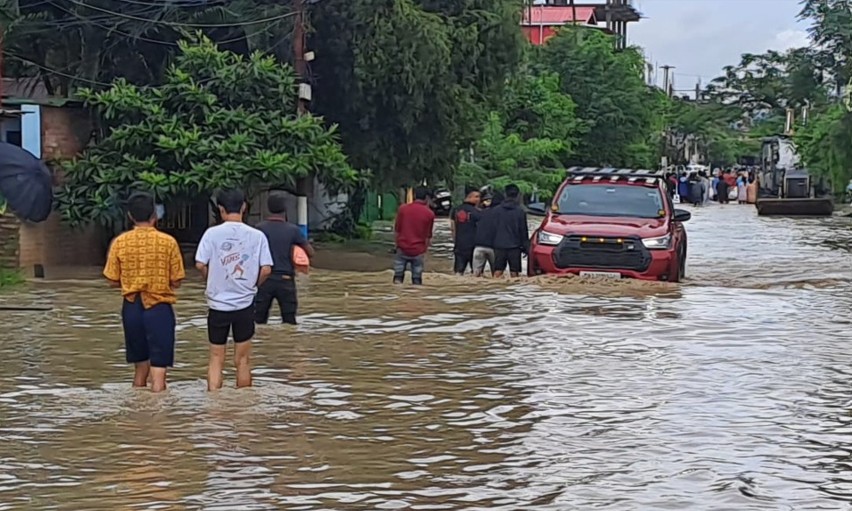
That climate change is for real needs no further proof than Cyclone Remal which is yet again devastating the Northeast, including Manipur. Last year the same cyclonic cloudburst hit Manipur and the other Northeastern states on May 25, and this year too it has arrived at about the same time on May 29 causing landslides and floods at many places, even take life tolls. Manipur too is suffering but thankfully so far there has been no lives lost.
What then must be the response of the state and people to this phenomenon of changes in rainfall cycle, and that too coming in devastating cloudbursts, causing landslides in the hills and floods in the plains.
By now most are familiar with the accepted strategies of the fight against climate change, given the growing global concern and commitment to mitigate climate change and its effects. Broadly, it will have to be a two-pronged approach. One is about fighting climate change itself to slow it down and ultimately reverse it. The other is to cope with the effects of climate change which has already happened. Both these strategies are important.
The fact also is, fighting climate change is a global enterprise and all that Manipur can do is to lend it mite to the effort. What is needed is to cooperate and go along with the global fight against what has been described as an existential threat for humankind, if not life on earth itself. This will mostly be about reforestation, lowering carbon emission etc.
On the local plane however, along with joining the global battle against climate change, the challenge is also to cope with the impacts of climate change which has already occurred. Cyclone Remal which now does seem is set to occur on an annual cycle is the most immediate example. Given the unpredictability of weather in the backdrop of climate change, who can say there will not be other equally devastating surprises awaiting in the future.
In the hills, the response will have to be about reforestation where forest covers have been destroyed so as to firm up the soil to mitigate landslide possibilities to the extent possible. Stone and rock mining must also be carefully assessed and moderated to ensure natural pace of flows of water along hill streams are maintained. The rocks on riverbeds act as natural check dams slowing down water flows therefore making it less damaging to the soil. They also check and delay flows of rain water to the valley below.
In the valley the problem is of floods. One or the other river of the many that flow into the valley either overflow their banks or breach them to inundate habitation areas and paddy fields, causing great losses and miseries.
Since the catchment areas of all these rivers are different and widely spread out, the pattern has been for some or many of the rivers to continue to flow below their danger marks while others overflow them. For instance, if there is heavy rain on the eastern face of the Koubru range in Kangpokpi district, Imphal river would swell, just as when there is heavy rain on the western face of the Shirui hill range, Thoubal river would swell. Likewise, for the Iril river to swell, there would have to be heavy rain in the Lakhamai, Ngamju, Khongdei etc., hillsides in the Senapati district.
One intuitive answer to the problem which becomes obvious after witnessing this pattern is, the government could think of linking these major rivers so that in emergencies brought by climate events like Cyclone Remal, waters from swollen rivers could be diverted to other rivers so as to lower their levels without risking the rivers that receive the diverted waters becoming swollen themselves. This could reduce flood risks when all rives are not swollen at the same time. And from the pattern witnessed even in the current situation, there has been seldom any situation when all rivers flow above the danger mark at the same time.
The other main cause for the proneness to floods in the Imphal valley is the progressive reclamation of wetlands as living spaces. To an extent this is understandable for population too has not been stagnant, and has been progressively increasing. However, this needs to be strictly regulated now. Probably living space expansion will now have to be vertical as apartments, not horizontal as homesteads.
As for the shrunken wetlands, probably the way forward is to develop what is remaining of them. This could to be about deepening the remaining areas of these wetlands so that they can accommodate the same volume of water they once could when their areas were spread wider. One such experiment is being done at Lamphelpat, and it remains to be seen how successful or otherwise this is as a flood control measure.
Once upon a time these wetlands acted as effective reservoirs for flood waters to drain into during cloudbursts and then when the rains subside, discharge them back into the rivers. Together with these wetlands, there were also an elaborate network of rather large drainage system called khongban. From every habitation areas, these khongbans diverted and drained excess water away into the wetlands. Reintroducing such a drainage system, but designed to suit modern cities and townships, may be what is called for today. The government’s planning and engineering departments need to put their heads together to work out and evolve a water management architecture which can be an effective answer to what is becoming a cyclic woe in the valley areas.

Editor, Imphal Review of Arts and Politics and author


1 thought on “River Linking May be the Answer to Floods in the Valley Caused by Cloudbursts Such as Those Brought by Cyclone Remal”
Climate Change Adaptation requires complete rethinking and reworking on how we live, how we redesign our villages and cities etc. Adaptation is about how we deal with Water. Too much, too little. Even our simple culverts requires a new size. This means to say that the traditional knowledge of rains, weather and thus based on that the size of the culvert has to be thought through. Even before river linking there are more things to do for each existing water system and thats where we focus. Unfortunately these are costly actions and those who are responsible must pay for this transition.
Comments are closed.