

Organic Integrity beneath the “Divide”
Colonialism has lasting impacts on the life of the people in those places which were once ruled – directly or indirectly – by the European imperial powers. In fact, there is a continuity between the colonial and the postcolonial in these regions. For instance, many of the legal instruments, institutions and practices in India have their moorings in the colonial period (e.g. police and Indian Penal Code). The continuity is not merely in terms of the institutions or the practices; it is also about the psychological make-up of the people. Indeed, colonialism is, as Ashis Nandy says, a “psychological” phenomenon as well. The world views and value orientations which shape the way people look at their world, within and without, are critically mediated by the colonial encounter. Even formal intellectual enterprises (e.g., sociology) in India are not free from the “epistemes of colonial modernity”. Therefore, not only our sense of identities but also our understanding of society, culture, history etc are often products of the colonial lens. Consequently, many of the contemporary predicaments are also outcomes of the colonial ideas and practices. The much talked about “hill-valley divide” in Manipur is one classic example of those plights. And the ongoing controversy over Koubru once again reminds us of that truth.
The state has taken a decision to declare Mt Koubru as a protected sacred site. This has been welcomed by the Meiteis in general. However, certain sections of the population in the state, particularly by the tribes who identify themselves as Kukis, have objected to the proposal. While the former insists that it is a sacred site which speaks of their “origin” and ancestors whom they worship, the later claims that it is a “majoritarian” attempt to usurp “tribal land”. In that, the recent contention over Koubru that has erupted amidst the Covid crisis has all the trappings of identity politics which has come to haunt Manipur for a long time. This politics reproduces what has been hitherto described as “the hill-valley divide” and the estrangement amongst communities in the state. Needless to say, any attempt to address this issue must begin with a dispassionate look at the what, when, how and wherefore of the “divide” itself. And we might as well start such an exercise with a critical look at certain basics facts about Manipur.
The Hills and The Valleys: A misrepresented relationship
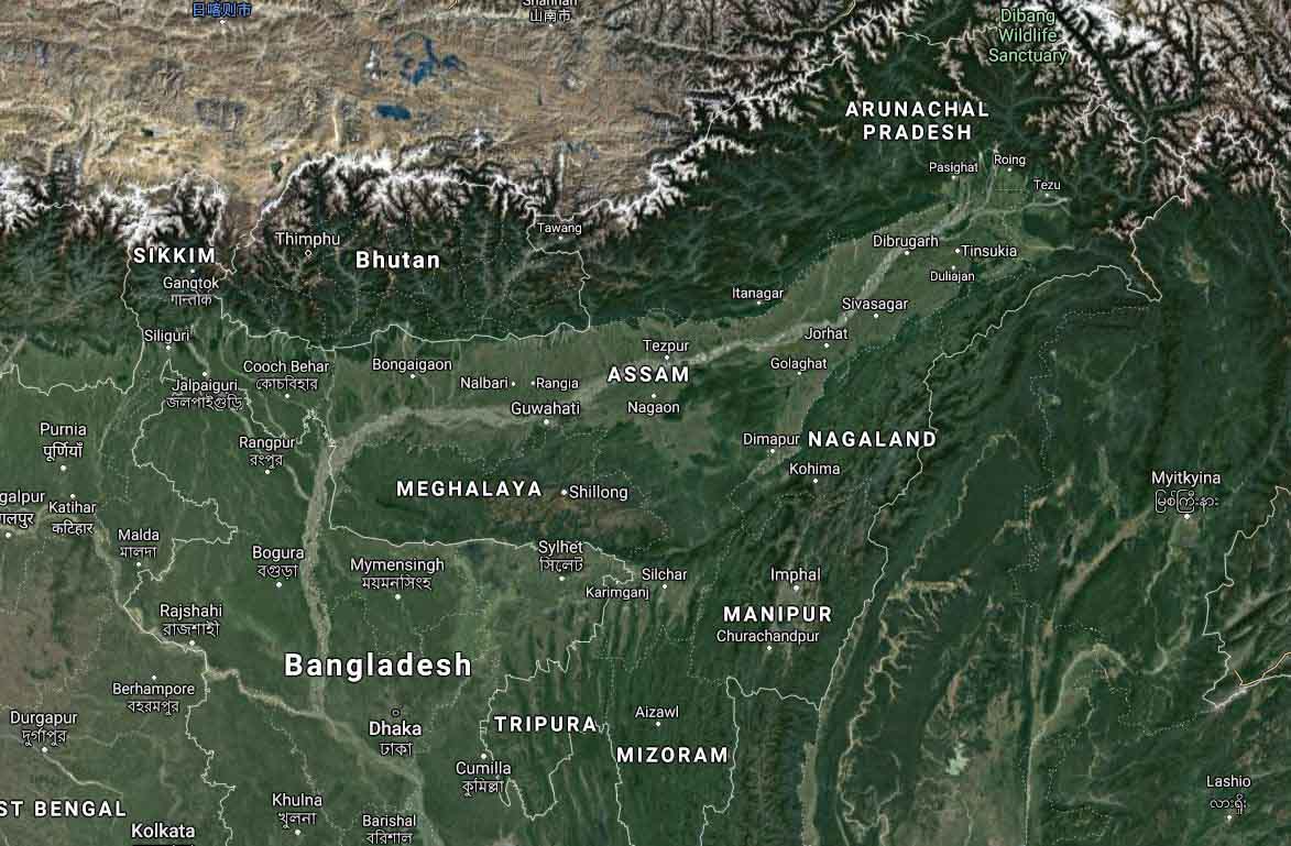
Some fifty millions years ago, in an epochal geological event, the Indian tectonic plate came to collide with the Eurasian plate. This led to various land formations and brought about long-term climatic changes on earth. One crucial outcome of that collision, a process which still continues and thereby making the region seismically volatile, is the formation of the Himalayas. These ranges of mountains run from the West-Northwest to the East-Southeast. The eastern Himalayas turn sharply towards the south around the Dihang gorge in Arunachal Pradesh to form the ranges of mountains and hills that mark the boundary between the present day Myanmar and India. The contemporary states of Nagaland, Manipur and Mizoram are parts of these mountains and hill ranges. The Arakan range in western Myanmar, which was also formed due to the said tectonic collision, runs from the Cape Negrais in the west of Irrawaddy Delta to Manipur in the North (continuing in this state as a part of, or connecting with, Manipur’s south-eastern ranges).
Like many other mountainous regions, these Himalayan ranges, including the ones which constitute states like Arunachal Pradesh, Nagaland, Manipur and Mizoram, have valleys or lowland areas or depressions between (or surrounded by) mountains and hills. These valleys are primarily formed by the movement of water bodies (e.g., flows of rivers) and take various shapes (e.g., V-shaped, U-shaped, flat-floored etc). And human settlements are found on the ridges, slops and valleys of these mountainous regions. Needless to say, the people who inhabit these settlements are linguistically and/or racially also related to one another. Taking note of this characteristic, some have termed this Himalayan region as the “Mongolian fringe” or “Mongoloid fringe”. Manipur, as a part of this mountainous/hilly region, is no exception to these characteristics.
However, despite the fact that the hills and valleys are integral parts of a mountainous region, in Manipur, there is a propensity to talk about the “hills” and the “valleys” as if they are unrelated or disconnected entities. Besides, despite the numerous valleys in the state, this landform (i.e., valley) is also mistakenly expressed in the singular (i.e., the valley). It must be reiterated that the oval shaped valley — located almost in the middle of the state surrounded by the ranges of mountains and hills and dotted with meandering rivers, water reservoirs (wetlands/lakes) and residual hills of the surrounding ranges and isolated pockets of hillocks— is not the only valley in Manipur. There are other well-known valleys as well (such as Khoupum Valley, Khuga Valley, Sajik Tampak, Dzuko Valley, Valleys of Jiribam and Moreh etc.). These are besides the other numerous valleys (mostly V-shaped ones, some with broaden floors) that are found amidst the ranges of mountains and hills in the state. In that, it is preposterous to talk of valley in the singular as if there is only one valley in Manipur.
Of course, this does not deny the fact that amongst all the valleys in Manipur, this oval shaped valley is the most prominent one — both in terms of the size and its historical place in the evolution of Manipur as a geo-political entity. Besides the capital city of Imphal, many other prominent towns (such as Thoubal, Kakching, Bishnupur, Moirang etc which also served as district headquarters) are also located in this valley.
Reducing the valleys into a singular expression is not the only flawed view. The relationship between the oval shaped valley and the hills is also mistakenly treated like that of the link between the North Indian plain and the Himalayas. Correspondingly, the relationship between the oval shaped valley and its surrounding mountains/hills is projected like the relationship between Uttrakhand (formerly, Uttaranchal) and the Indo-Gangetic plains of UP, or, for that matter, between Himachal Pradesh (formerly, hills areas of Punjab) and the plain of the Indian state of Punjab.
The fact is that the Himalayas and the North Indian plain are two separate entities which were created by the tectonic collision. While the former is the elevated area while the latter is the depression which was later on filled with sediments brought by the rivers from the Himalayas. Unlike this Indo-Gangetic plain which is not surrounded by mountains/hills, the oval shaped valley of Manipur is a part of the elevated mountainous/hilly area created by the tectonic collision. And like all other valleys in the state, it is also surrounded by mountains/hills.
It is crucial to note that this oval shaped valley is not confined to the so-called “valley districts” only. It runs into the so-called hill districts like Churachandpur. In fact, geographically speaking, the district headquarters of Churachanpur is located at the southern tip of the oval shaped valley as it comes to connect with the southern hills of the state; its elevation is 914 m, barely some 130 m above the capital city of Imphal (786 m). Similarly, Kangpokpi District headquarters is located at the extended northern tip of the oval shaped valley at an elevation of 992 m. This is in contrast to some other district headquarters in the state which are at a higher elevation (e.g., Ukhrul District headquarters is at about 2020 m) or those which are relatively at a lower level (e.g., Senapati District headquarters is at about 1440 m; it is situated in and around the valley adjoining the Senapati River).
In short, the geological/geographical reality of Manipur speaks of not only the mountains/hills and the valleys but also an intimate connection between these landforms as an integral feature of the state. And this intimacy between the mountains/hills and the valleys is heightened by the major river systems in the state as well.
The Rivers: The lifelines of a habitat
Most prominent rivers (such as Imphal River, Thoubal River, Iril River etc) originate from the northern mountains and hills of the state and all flow towards the south. There are also numerous lakes and wetlands which served as the water reservoirs. And these rivers flow out of the state as one river (the Manipur River) and ultimately it drains into the Bay of Bengal (after running through the southern hills of the state and joining Myittha River, a tributary of Chindwin River, in Myanmar). It is this river system which has played a major role in creating the oval shaped flat-valley by depositing sediments and eroding the rocks/soil (thereby, widening and flattening the area) over thousands of years. This geological fact — that this oval shaped valley has fluvial and lacustrine origin — has been noted by many geologists.
Similarly, the other major river system (associated with the Barak River) marks the western side of Manipur along the western mountain/hill ranges and the valleys. The Barak River originates from the north-western mountains of the state and runs briefly towards the west before turning southwards, partly forming the boundary between Nagaland and Manipur before it runs inside the state all the way to Tipaimukh (Pherzawl District) in the south at the border between Manipur and Mizoram. From there, it takes a sharped U-turn to run towards the north (forming the border between Assam and Manipur) through the border districts of Pherzawl and Jiribam before entering into Assam.
Incidentally, unlike the direction of these river systems in Manipur, major rivers in Nagaland run from the south to the north or North-west. Similarly, major rivers in Mizoram (e.g., Tlawng River) flow from the south to the north or from the east to the south-west, with some exception, especially on its border with Myanmar (e.g., Tiau River).
Thus, the mountains/hills, the valleys and the rivers and other water bodies form the integral constituents of the state as a geo-political entity. In fact, if one were to take a bodily metaphor and look at Manipur as an organic system, then the ranges of mountains and hills are the skeletons and muscles that constitute the body and its limbs, the rivers are the lifelines — arteries and veins — that supply the life sustaining waters while the valleys are the body cavities that house vital organs like the farming lands etc. Indeed, for the denizens of Manipur who settle on its ridges, slops and valleys or island hillocks and floating bio-masses (phumdis) in the Loktak Lake, it is this organic linkages amongst its physical landscape — the mountains/hills, the valleys, the rivers and the lakes — that nature and sustain life. Any disruption in any part is bound to affect the other component and life thereof (e.g., deforestation in the mountains/hills and floods in the valleys).
Incidentally, this organic integrity, the natural features that characterize the topography of the state, is also further reinforced by the fact that majority of the population who inhabit these terrains are closely related, particularly in terms of cultural, linguistic and racial features. From the origin myths and to the folklores of various communities to the written and documented sources, all speak of these cognate characters and ties amongst of the inhabitants. And over the centuries, with the emergence of a state — germinated from the wetland cultivation in the oval shaped valley and the surplus thereof followed by the consequent imperatives like mobilization/management/regulation of labour force etc, the geographical and demographic character of Manipur has also come to acquire a substantive form in terms of polity. Thus, the Indian Constitution acknowledges this polity in its first schedule by referring to Manipur as a geo-political entity that existed “before the commencement” of the Constitution itself (This Constitution was adopted on 26 November, 1949 and came into force on 26 January, 1950).
However, it is this historicity of the organic character of the state which has been distorted, particularly during the last century, and further ruptured by the various mobilizations based on identity politics. It is these developments, which are critically rooted in the colonial discourses and practices introduced in this part of the world by the European colonizers, that have produced the “hill-valley divide” in the state. And the said misrepresentations and schism in the state have got a new lease of life due to the coloniality of the postcolonial and the contemporary competitive politics.
To be continued

The author is a social and political psychologist who teaches social psychology and sociology at the Jawaharlal Nehru University, New Delhi

5 thoughts on “Koubru Calling: Beyond the Twisted Lens of Colonial Modernity and Myopia of Competitive Politics – Part 1”
Very interesting thoughtful and informative. Wish to continue reading it. Thank you.
Thank you
Very interesting to read. Never though about this organic integrity, Manipur being a Geopolitical entity and valleys.. The examples given by comparing relationship between Punjab & Himachal, Uttrakhand & UP, the river systems in Nagaland and Mizoram are so clear to understand Manipur’s uniqueness for a layman like us. Please keep wring such articles. Looking forward to the next part. Thank you so much for this article.
Thank you. Plea do go through the second part.
As a researcher in Earth Sciences/Geology, its really glad and impressive to see a Professor in Social Sciences (Oja Bimol) writing about my domain in a very engaging manner that too about a place where my roots belong. Its really a well researched and inter-disciplinary article written in a very meticulous manner. Reported geological ages of some the rock units from Ukhrul (Ophiloites) comes around 100 Ma which were originally part of the oceanic crust now emplaced on the continental part due to tectonic movements (Collision of Indian plate and Eurasian plate) and our Imphal Valley is mostly alluvium and sediments which are derived from these elevated portions comparatively younger in age (Pleitsocene-2.5million yrs-11000 yrs approx). Unfortunately I have not worked on lithologies in Manipur till date but I do have some broad knowledge from the field trips and lectures during my graduation and published literatures.
Comments are closed.